Authorities are urging residents to stay alert as the remnants of Tropical Cyclone Arthur move inland along the northeastern Texas coast. The storm has been downgraded to a post-tropical cyclone, and all tropical storm warnings have been canceled, according to the National Weather Service.
The system is expected to bring heavy rainfall totals of 5 to 10 inches across Louisiana, Mississippi, Alabama, Georgia, and the Florida Panhandle. Isolated areas could see up to 20 inches of rain through early Friday, resulting in widespread flash flooding and potential road closures.
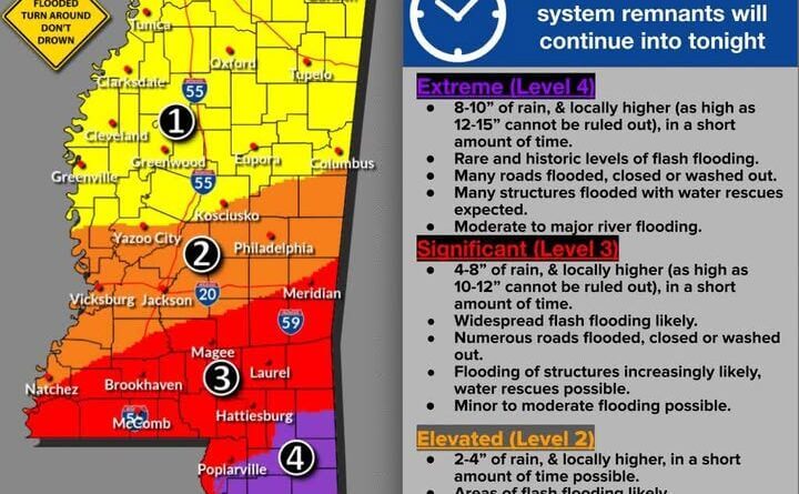
Gulfport and Poplarville in Mississippi could receive 8 to 10 inches of rain, with higher amounts possible in some areas. Flooding of roads and structures is likely, and water rescues may be necessary. Moderate to major river flooding remains a concern in affected regions.
Other cities such as McComb, Hattiesburg, Laurel, Meridian, Magee, and Brookhaven could see rainfall between 4 and 8 inches, with localized totals reaching 10 to 12 inches in a short period. Flash flooding is probable, and many roads could become impassable.
In central Mississippi, Yazoo City, Vicksburg, Jackson, Philadelphia, Natchez, and Kosciusko may experience 2 to 4 inches of rain. Flash flooding is expected, with some road closures and potential threats to structures. Minor river flooding is also a possibility.
The heaviest rain is forecast between 12 a.m. Thursday and late tonight. Officials advise residents not to drive through flooded roads. The message remains clear: turn around, don’t drown. Stay safe, Mississippi.